Viz: Regional distrubution of flora around the administrative areas of Cyprus
Description: The aim of this data story is to better understand the distrubution of flora around Cyprus based on the administrative geographical zones and regions of the island..
Techniques used: Geospatial analytics, data visualizations, AI and computer vision (Arslan Amin, Chirag Padubidri)
Data story:
Cyprus, an island nation in the eastern Mediterranean, is a hotspot of flora biodiversity, boasting over 1,900 plant species, of which approximately 140 are endemic—found nowhere else in the world. Its unique geographical position, diverse habitats (from coastal plains to mountainous forests), and Mediterranean climate create ideal conditions for a rich variety of flora. Iconic species include the Cyprus cedar (Cedrus brevifolia) and the Cyprus tulip (Tulipa cypria). However, habitat loss and climate change pose threats to this biodiversity, making conservation efforts crucial. Cyprus' flora not only contributes to its ecological richness but also plays a vital role in its cultural and natural heritage. The purpose of this data story is to understand the distribution of flora among the different villages, towns, cities, regions and administrative zones in general of the island of Cyprus.
This data story is empowered by the GAEA geospatial tool, developed by the SuPerWorld research group of the CYENS Center of Excellence. GAEA provides 26 environmental services [1], including information about tree species and vegetation around Cyprus. As part of a pilot project using GAEA (Cyprus TreeMapper), we developed an AI model, which used high spatial resolution satellite imagery to detect and count all trees around Cyprus. The final product was a GIS layer that detected and counted all trees around the island. A total of 54,731,274 trees had been identified, with more than 90% accuracy. In the 10% error, there are trees that were occluded or highly dense forested areas which make individual tree detection and counting difficult. Based on these results, we created the following infographics.
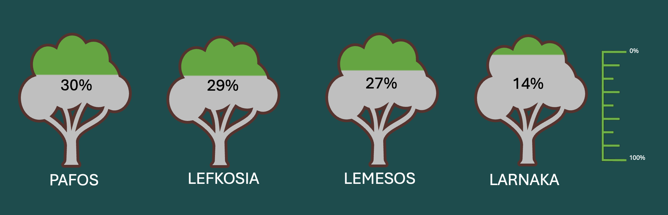
First, we examine the percentage of trees across the main districts of the island, illustrated in the figure below. Pafos tops the chart with 30% of the trees of the island, while Lefkosia and Lemesos are close behind with 29% and 27%. Larnaka has only 14% .
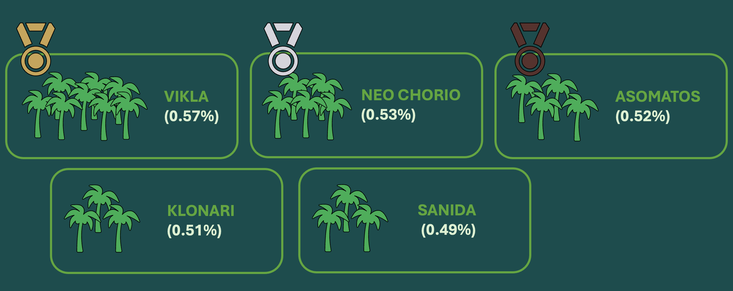
Then, we studied which were the top-5 communities/villages based on tree count in relation to their total area in square kilometers. This infographic was based on the Tree Density Index [2], which shows how many trees each village or community has, compared to its total area. This indicates which communities have a higher density of trees. In the figure below, we can see that the winner is Vikla, followed by Neo Chorio, Asomatos, Klonari and Sanida. Well done to the citizens of those communities. Take good care of your flora wealth!
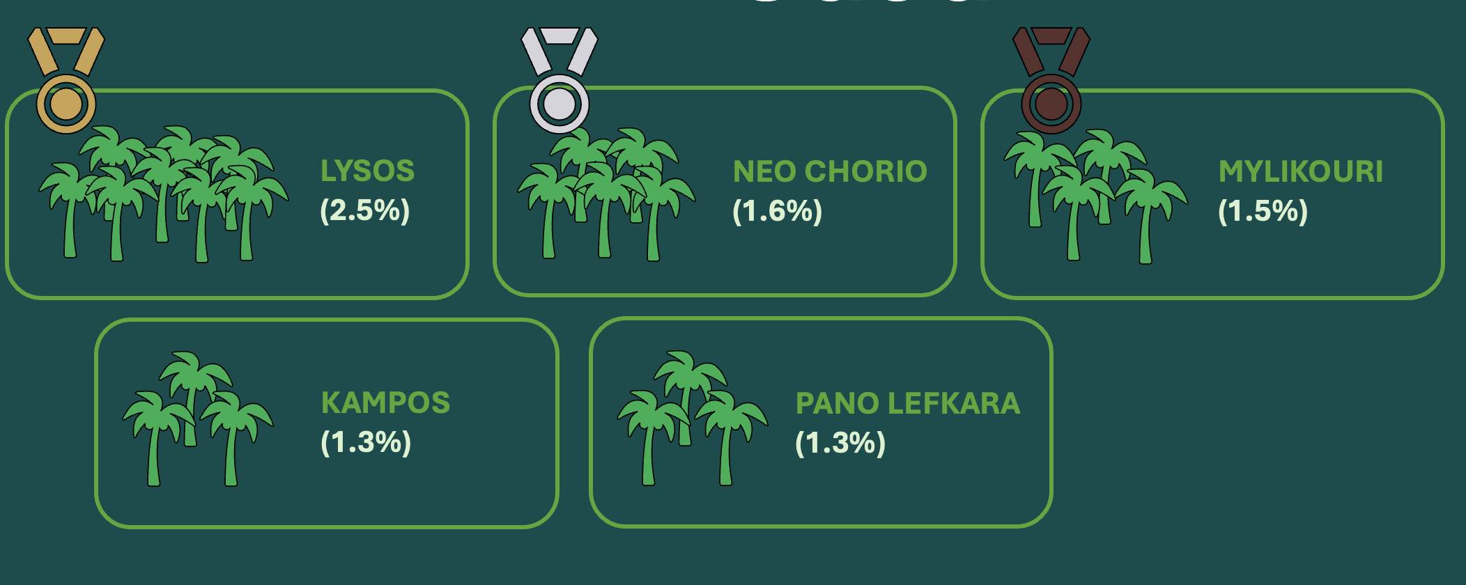
In a similar effort, but this time considering the “contribution” of each village/community to the total number of trees around Cyprus (i.e. total percentage of trees located inside the geographical zone of some community), we created the following infographic. The awards now change, as Lysos is the winner hosting 2.5% of the total trees on the island, ahead of Neo Chorio and Mylikouri, followed by Kampos and Pano Lefkara.
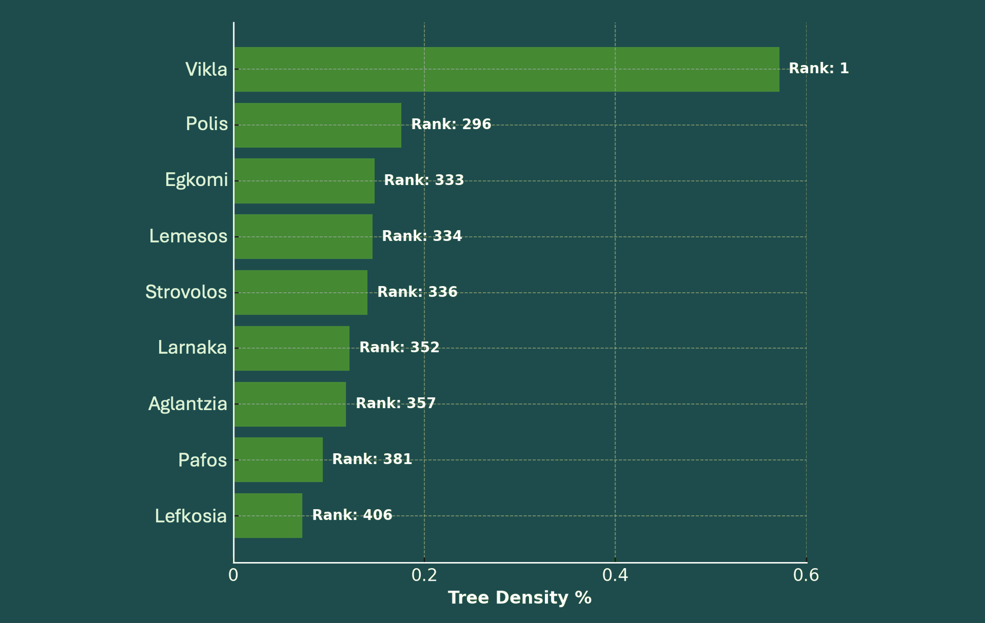
After, we compard tree density across all the municipalities of the island. The following infographic compares the tree density per square kilometre (%) for all municipalities and communities across Cyprus, showcasing where they stand in terms of tree density. Only selected municipalities are visualized in the infographic below. The figure gives a clear view of where large municipalities stand regarding green space by considering their overall ranking across all municipalities and communities. We can observe that the main municipalities of the island are not rich in greenery compared to smaller, local communities, as their ranking is between 300-400 more or less.
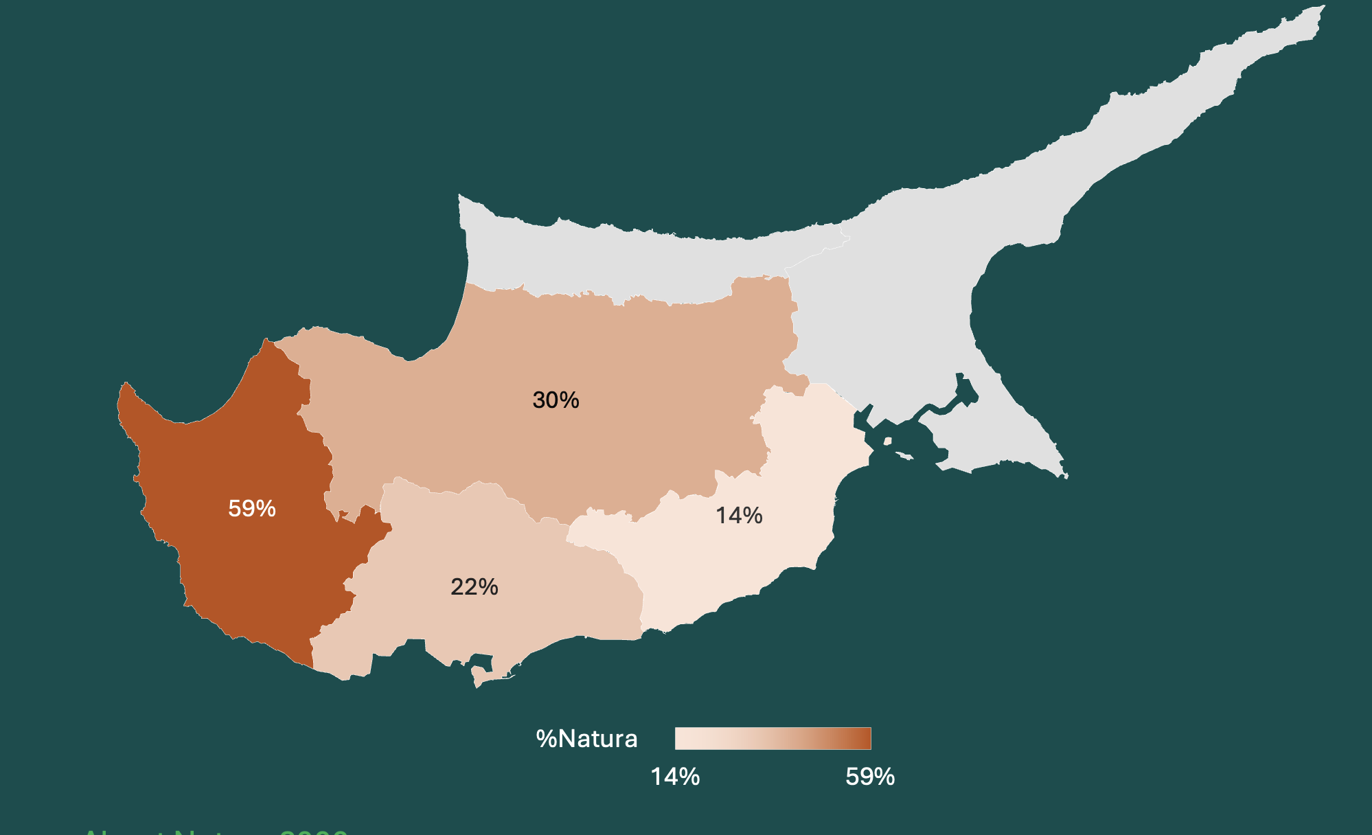
In the final infographic, we indicate the percentage of each district of the island which is designated as “NATURA 2000” area [3-4]. Paphos has the highest percentage (59%, due to the Paphos forest), followed by Nicosia (30%, due to Troodos).
Conclusion
This data story reveals important insights about the flora distribution around the island of Cyprus. Such studies are important for policymakers and local authorities to prioritize protection and conservation of sensitive areas, and to allocate their resources more efficiently. This study aligns nicely with our earlier work on classifying tree species around Cyprus [5]. Both studies combined can provide an important tool for better policy- and decision-making in terms of protecting the forestry of the island from various stressors and threats, especially under the prism of a changing climate around the globe.
References
[1] A. Jamil, Chirag Padubidri, Savvas Karatsiolis, I. Kalita, Aytac Guley, and A. Kamilaris, “GAEA: A Country-Scale Geospatial Environmental Modelling Tool: Towards a Digital Twin for Real Estate,” Progress in IS, pp. 177–199, Jan. 2024, doi: https://doi.org/10.1007/978-3-031-46902-2_10.
[2] Crowther, Thomas W., Henry B. Glick, Kristofer R. Covey, Charlie Bettigole, Daniel S. Maynard, Stephen M. Thomas, Jeffrey R. Smith et al. "Mapping tree density at a global scale." Nature 525, no. 7568 (2015): 201-205.
[3] https://www.eea.europa.eu/themes/biodiversity/natura-2000/the-natura-2000-protected-areas-network
[4] https://natura2000.eea.europa.eu
[5] Arslan Amin, Andreas Kamilaris and Savvas Karatsiolis, A Weakly Supervised Multimodal Deep Learning Approach for Large-Scale Tree Classification: A Case Study in Cyprus, Remote Sensing Journal, vol. 16, no. 23, 4611, December 2024. https://doi.org/10.3390/rs16234611