Viz: Flora and geomorphology in Cyprus: Patterns and relationships
Description: The aim of this data story is to better understand the relationship between the dominant flora around Cyprus and the geomorphological characteristics around them..
Collaboration with: Joost ter Braake (University of Twente)
Techniques used: Geospatial analytics, data visualizations, AI and computer vision (Arslan Amin)
Data story:
Cyprus lies in a biome, characterised as ‘Mediterranean Forests, Woodlands, and Scrub’, hosting a wide variety of vegetation across its landscape. In this data story, we will explore how geospatial data may be used to better understand the relationship between various flora and the geomorphological characteristics of their landscapes. This data story is empowered by the GAEA geospatial tool, developed by the SuPerWorld research group of the CYENS Center of Excellence. GAEA provides 26 environmental services [1], including information about tree species and vegetation around Cyprus, as well as insights about the geomorphological aspects of the island such as elevation, slope, aspect, soil type and texture, etc. Tree classification is based on an AI model taking satellite imagery as input, which classifies trees in 13 different classes, which are the ones evident from high spatial-resolution satellite imagery. These classes are: walnut trees, fig trees, pines (brutia pine vs. black pine), carob trees, olive trees, grape trees (vine), fruit-bearing trees (e.g. citrus and apple trees), golden oak, palm trees, Cyprus cedar, banana trees and juniper trees.
Filling in the blanks
After our initial analysis, the spatial distribution of the trees seems to follow specific patterns. Let’s take figs (light blue colour) and walnuts (dark red colour) as an example:
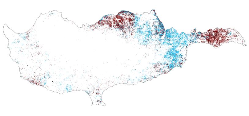
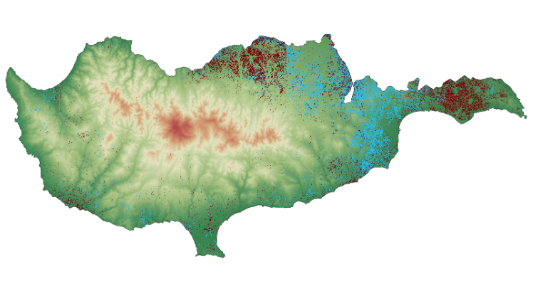
Your eyes may first be drawn to the northeast, where these trees appear to be quite common compared to their sparse presence around the coasts. Then, you may notice the blank void in the middle of the country. If we add an elevation map underneath, we are likely to get a clear picture of the reason we see this spatial distribution around the island. It would appear that what these trees share in common is that they prefer to grow at lower elevations.
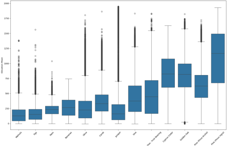
We can move one step further, creating box plots for each of the 13 tree classes. The centre of each box marks the average elevation where each tree occurs, with whiskers and individual dots extending beyond each box to indicate the full range of elevation where each tree class prefers to grow, even where it is less common, or where there are individual outliers. Walnuts and figs show a very similar pattern, preferring lower elevations as compared to trees on the right side of the plot – such as pines, Cyprus Cedar and Golden Oak – which mainly grow in the mountains of the island.
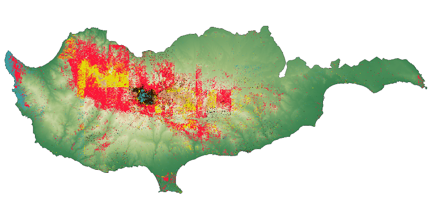
Focusing on trees growing almost exclusively in these central mountains (Paphos Forest and the Troodos Mountain), below we can see the distribution of brutia pine (red colour), black pine (black colour), Golden Oak (yellow colour), and Juniper (light blue colour). Juniper appears to be a special case, present in two large clusters to the far west (Akamas peninsula) and in the central heights of the mountains.
Can you thrive on a rock?
To gain a deeper understanding of the patterns we are seeing it is necessary to consider other geomorphological dimensions as well, such as the slope, aspect and soil type. As we zoom into the Troodos mountain, we can overlay the soil types over the map. We find Rock (yellow colour) as the dominant soil type in this region, with small patches of Loam (blue colour) and Clay (purple colour) also present.
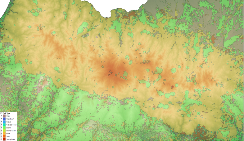
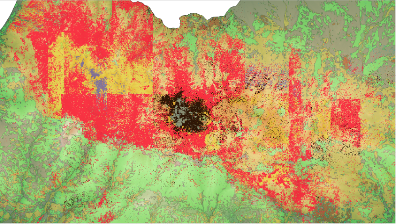
By now overlaying our tree classification data, we may learn more about the relationship between tree species and soil types. Rocky soil, which permits little depth for water, is fine for these trees, though they appear scattered also across loam. Further, we can see black pines (black colour) in the figure below around the highest areas of the Troodos mountain.
Pursuit of the sun
We can also consider slope and aspect with respect to our tree species. We noticed only a few differences with regard to preferences for slope, as brutia pine prefers slopes a few degrees higher than black pines in general (23.98 degrees). Cyprus Cedar and Golden Oak tend to grow also on higher slopes, reaching 26-27 degrees.
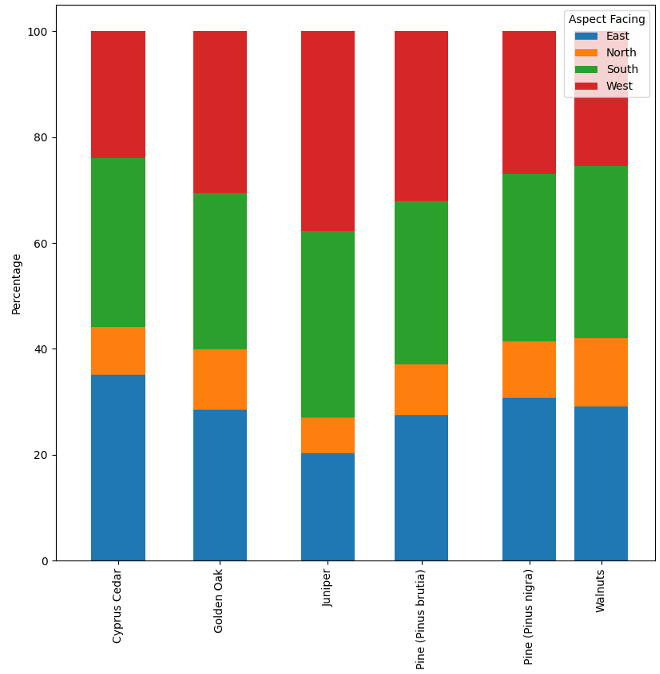
Aspect was considered as the nearest cardinal direction a slope faces, i.e. north, east, south and west. In the following figure we find some interesting patterns. Brutia pine prefers a west facing slope at 32.04% of all incidents vs. 26.84% in black pine. We can observe a strong preference for south over north among all tree classes, which receives more light from the sun in the northern hemisphere.
Black vs. Brutia pines: A love and hate relationship
The two types of pines common to Cyprus may have a complicated relationship. In a recent study, Petrou et al. showed that black pines grow adjacent to brutia pine in “mixed stands”, and that brutia pine promotes biodiversity, especially in areas with high quality soil [2].
Brutia pine seems to require a larger crown area than black pine [3]. Since black pine can grow taller than brutia pine, while needing less space for its canopy, it may overshadow its cousin, throwing these shared stands off balance. As brutia pine plays an important role in promoting biodiversity, it is important to monitor where and in what geomorphological conditions black pine crowds out brutia pine.
With respect to soil depth, the lowest depth corresponds with bedrock, whereas deeper soil depths are found in loam, especially clay loam and clay proper. By correlating our tree species with soil, we find that brutia pine is found predominantly on rocky soil (83.97% of cases), and secondly in loam (12.64%). It shows up to some extent in all soil types, confirming older research claims that this species can adapt to any soil type present on Cyprus [2]. Interestingly, though black pine also grows mostly on bedrock (78.54% of cases), a larger percentage of black pine is found growing in loam and clay than its cousin, the brutia pine.
Conclusion
By exploring this geospatial information, we have gained significant insights into what geomorphological characteristics are relevant to the flourishing of several types of trees which are dominant in Cyprus. The pines of Cyprus have a special relationship, and tools such as GAEA have an important role to play in monitoring those relationships, shaping relevant policies and decisions whenever needed, in order to preserve biodiversity.
You can more info about this study at this scientific publication:
Arslan Amin, Andreas Kamilaris and Savvas Karatsiolis, A Weakly Supervised Multimodal Deep Learning Approach for Large-Scale Tree Classification: A Case Study in Cyprus, Remote Sensing Journal, vol. 16, no. 23, 4611, December 2024. https://doi.org/10.3390/rs16234611
References
[1] A. Jamil, Chirag Padubidri, Savvas Karatsiolis, I. Kalita, Aytac Guley, and A. Kamilaris, “GAEA: A Country-Scale Geospatial Environmental Modelling Tool: Towards a Digital Twin for Real Estate,” Progress in IS, pp. 177–199, Jan. 2024, doi: https://doi.org/10.1007/978-3-031-46902-2_10.
[2] P. Petrou et al., “Comparison of the Stand Structure Diversity of Open Pinus brutia Ten. Forests in Areas of Different Productivity in Central Cyprus,” Forests, vol. 14, no. 11, p. 2200, Nov. 2023, doi: https://doi.org/10.3390/f14112200.
[3] K. Ferhat and T. Osman, “Onset of canopy closure for black pine, Turkish red pine and Scots pine forests,” Journal of Forest Science, vol. 64, no. No. 5, pp. 224–229, May 2018, doi: https://doi.org/10.17221/153/2017-jfs.